Philippines: Tropical depression to bring heavy rains, severe winds
Pacific weather disturbance, codenamed “Amang”, gathers strength in east
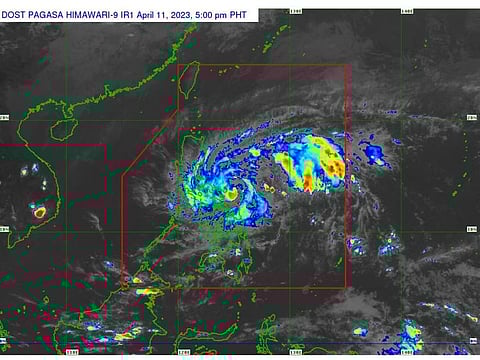
Manila: A weather disturbance known as low-pressure area (LPA) seen off eastern Philippines on Monday, has progressed into a tropical depression (TD) on Tuesday.
The weather pattern, locally codenamed “Amang”, continues to move westward towards the northern coast of the eastern island of Catanduanes, Philippine weathermen said in their latest (April 11) update.
Forecasters of the Philippine Atmospheric Geophysical and Astronomical Services Administration (Pagasa) said rains with gusty winds could bring flash floods and landslides in the Bicol Region, Quezon, Marinduque, and Samar provinces.
As of 5pm on Tuesday, the centre of the eye of "Amang" was estimated at 130 km East Northeast of Virac, Catanduanes or 250 km East of Daet, Camarines Norte (14.1 °N, 125.3 °E).
A wind Signal No. 1 has been raised in several areas which may experience strong winds (strong breeze to near gale strength), which may pose minimal to minor threat to life and property.
Heavy rains expected
Pagasa expects heavy rains (50-100 mm) in the Bicol Region and Northern Samar, while intense rains (100-200 mm) are expected in the northern portion of Quezon province and the eastern portion of Laguna, near Manila.
Heavy rains (50-100 mm) are also expected in Rizal province (near Manila), southern portion of Aurora, the rest of Laguna and Quezon provinces.
“Under these conditions, flooding and rain-induced landslides are possible, especially in areas that are highly or very highly susceptible to these hazard as identified in hazard maps and in localities that experienced considerable amounts of rainfall for the past several days.”
“For the next 24 hours, ‘Amang’ is forecast to track generally westward or west northwestward towards Bicol Region today (April 11) before turning west northwestward or northwestward for the remainder of the forecast period.
Landfall within next 9 hours
“While the current track forecast shows that the tropical depression will remain offshore over the waters east of Luzon for the next 3 days, the forecast confidence cone shows that a landfall scenario over the Bicol Peninsula area is not ruled out (may pass over or very close near Catanduanes), especially for the next 9 hours,” Pag-asa said.
Meanwhile, the island of Romblon and the rest of the Visayas can expect cloudy skies with scattered rainshowers and thunderstorms.
On the other hand, the capital Manila and the rest of the country could experience partly cloudy to cloudy skies with isolated rainshowers or thunderstorms. Flash floods or landslides are are expected during severe thunderstorms.
“The public and the disaster risk reduction and management offices concerned are ad vised to take all necessary measures to protect life and property,” it added.
The Pagasa regional services divisions may issue local heavy rainfall warnings, rainfall/thursdanstorm advisories and other severe weather information specific to their areas of responsbility as appropriate,”
Typhoon prone
The Philippines is located in the western Pacific Ocean and is a tropical country with a warm and humid climate. The country is prone to typhoons, also known as tropical cyclones due to its geography.
The Philippines is located in the so-called “typhoon belt”, an area in the western Pacific Ocean where tropical cyclones tend to form and move through.
The country is situated along the eastern edge of the typhoon belt, making it particularly vulnerable to typhoons.
Warm sea surface temperatures also contribute to this phenomenon.
Tropical cyclones need warm ocean water to form and strengthen. The Philippines is located in an area where sea surface temperatures are warm enough to support the development of tropical cyclones.
The Philippines is an archipelago with many mountainous regions. These mountains can act as a barrier to typhoons, causing them to weaken as they move over land. However, they can also cause localized flooding and landslides.
Another possible reason is climate change: There is evidence to suggest that climate change is increasing the frequency and intensity of typhoons in the western Pacific, including the Philippines.
Warmer ocean temperatures, rising sea levels, and changes in atmospheric circulation patterns may be contributing to this trend.
The Philippines has experienced some of the strongest and deadliest typhoons in history, highlighting the need for effective disaster preparedness and response efforts.


