Back-to-back: 2 tropical cyclones threaten eastern Philippines
Heavy to intense rains could inundate low-lying areas, warns weather bureau
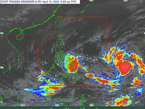
Manila: A low pressure area (LPA) has intensified into a tropical cyclone, threatening several Philippine provinces from Sunday, even as a another storm is spotted east of the country.
More areas have been placed under Tropical cyclone wind signal (TCWS) No. 2 after "Agaton" further intensified, the Philippine Atmospheric, Geophysical and Astronomical Services Administration (Pagasa) said on Sunday.
The first storm, known as “Agaton”, was seen over the coastal waters of Guiuan, in Eastern Samar as of 5am local time (1am in UAE) on Sunday (April 10, 2022).
In its 8 am bulletin, Pagasa said the center of “Agaton” was spotted over the coastal waters of Guiuan, Eastern Samar moving "west northwestward at 10 km/h with sustained winds of 75 kph and gusts of up to 105 kph.
The weather bureau said the following areas were placed under TCWS No. 2:
Pagasa said winds may reach gale-force in strengthen in any of the areas under TCWS No. 2 throughout the passage of Agaton.
Singnal No. 1
Meanwhile, the rest of Eastern Samar; the rest of Samar, Northern Samar and Biliran; the rest of Leyte, Southern Leyte; and the rest of the northeastern portion of Cebu (Daanbantayan, Medellin, Bogo City, Tabogon, Borbon) including Camotes Islands are now under tropical storm warning system (TCWS) No. 1.
“These conditions may be risky for most seacraft,” PAGASA warned.
It added that areas under TCWS No. 1, on the other hand, will experience strong winds that “maybe risky for hose using small seacraft.
Erratic move
“Agaton” is forecast to move erratically or remain almost stationary over the southern portion of Samar Islands and its coastal waters due to weak steering environment.
In a 12-hour forecast issued Sunday (valid till 2 pm), forecasters expect the first, slow-moving cyclone to be over the coastal waters of Mercedes, Eastern Samar, before moving into the vicinity of Quinapondan, Eastern Samar 12 hours later (2am on Monday, April 11).
Agaton, the first cyclone this 2022, is expected to hit several neighbouring provinces with moderate to severe rains.
A second cyclone was spotted moving in from the Pacific to the west — and may hit eastern Philippines too.
Light to moderate rain, with at times heavy rain:
Flood alerts were raised in at least 6 Philippine regions, with rivers seen overflowing and inundating low-lying areas.
Weathermen noted that daily rainfall in March 2022 on the southern island of Mindanao already exceeded previous levels, recorded in 1982.
Heavy rains are triggered by the storm at the tail-end of the so-called “La Niña” phenomenon. Forecasters said the second cyclone has a maximum sustained winds of 55 km/h, and gustiness of up to 70 km/h.


