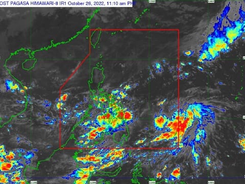
Philippines: Direct hit by typhoon ‘Paeng’ threatens country
Tropical Cyclone Warning Signal No. 4 could hit country's north over the weekend

Manila: A tropical depression that could turn into a typhoon, codenamed “Nalgae”, is threatening the Philippines with strong gusts and gale-force winds.
Residents in a huge swathe of the country had been warned on Wednesday of risk of flooding and landslides, possibly interrupting maritime travel in the country's eastern provinces and nearby islands.
A Tropical Cyclone Wind Signal (TCWS) may be raised in some parts of Eastern Visayas and Bicol Region Thursday morning — with possible maximum wind equivalent to TCWS No.4.
Forecasters stated at 11am on Wednesday (October 26) that the typhoon, locally codenamed “Paeng”, could form into tropical storm category No. 4 in the next 24 hours.
Residents are advised to get updates from Pagasa, the Philippine weather bureau.
Paeng is currently seen heading and approaching Northern Luzon where its centre may pass close or make landfall on Sunday or Monday.
Updates:
Location (11:00 am, October 26):
Path
Local forecasters from Pagasa, said Paeng is expected to move further west until Thursday (October 27, 2022), and is seen moving further west-northwest.
Because of the uncertainty of its path, changes in its future track are still expected, said weathermen.
It is expected to strengthen and become a Tropical Storm within 24 hours. It is possible that “Paeng” will strengthen while moving in the Philippine Sea and reach Typhoon status on Saturday.
In case it becomes a Tropical Storm under Japan Meteorological Agency (JMA), it will be given the international name “Nalgae”.
Heavy rains
The typhoon threatens the northern island of Luzon, based on tracking data. Currently, the trough of the typhoon is affecting large parts of the Visayas and Mindanao where it is pouring stormy rains.
From Friday to Saturday morning, it is possible to experience heavy to heavy rains in a large part of the Bicol Region.
Moderate to heavy rains are possible in the following provinces/regions:
Light to moderate rains
Light to moderate rains are expected in the following areas:
Saturday to Sunday
From Saturday to Sunday, it is possible to experience heavy to very heavy rains in the following areas.


