4.8 magnitude earthquake hits Batangas, felt in parts of Metro Manila
The tremor hit at 12.43am, its epicenter traced to 2 kilometers northeast of Calaca town
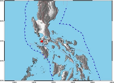
A magnitude 4.8 earthquake struck the province of Batangas just after midnight on Wednesday, shaking parts of Luzon, according to the Philippine Institute of Volcanology and Seismology (Phivolcs).
The tremor hit at 12.43am (local time), its epicenter traced to two kilometers northeast of Calaca town. The quake was shallow, only five kilometers deep, which explains why the shaking was sharp even if the magnitude wasn’t unusually high.
In Batangas, the towns of Sta. Teresita, Lemery and Cuenca reported intensity IV shaking, the kind strong enough to rattle furniture and wake light sleepers. Carmona in Cavite, Muntinlupa City, and Guinayangan in Quezon logged the same strength on Phivolcs’ instruments.
Metro Manila wasn’t spared either. Quezon City residents felt Intensity III, described as weak but noticeable. Makati barely stirred at Intensity II. Phivolcs said nearby towns in Cavite and Laguna also registered light shaking.
The Philippines is located on the Pacific Ring of Fire, which is known for its high seismic activity.
PHIVOLCS Earthquake Intensity Scale (PEIS)
Intensity II - Slightly felt
Felt by few individuals at rest indoors. Hanging objects swing slightly. Still Water in containers oscillates noticeably.
Intensity III - Weak
Felt by many people indoors especially in upper floors of buildings. Vibration is felt like one passing of a light truck. Dizziness and nausea are experienced by some people. Hanging objects swing moderately. Still water in containers oscillates moderately.
Intensity IV - Moderately strong
Felt generally by people indoors and by some people outdoors. Light sleepers are awakened. Vibration is felt like a passing of heavy truck. Hanging objectsswing considerably. Dinner, plates, glasses, windows and doors rattle. Floors and walls of wood framed buildings creak. Standing motor cars may rock slightly. Liquids in containers are slightly disturbed. Water in containers oscillate strongly. Rumbling sound may sometimes be heard.
Ring of Fire
The Ring of Fire, also known as the Circum-Pacific Belt, traces the meeting points of many tectonic plates, including the Eurasian, North American, Juan de Fuca, Cocos, Caribbean, Nazca, Antarctic, Indian, Australian, Philippine, and other plates, which all encircle the large Pacific Plate.
Why is the Philippine frequented by earthquakes?
The reason is because it straddles a number of active earthquake fault lines. Faults allow blocks in the Earth's crust to move relative to each other. These movement may occur rapidly, usually in the form of an earthquake — or may occur slowly, in the form of what geologists describe as "creep". Most faults produce repeated displacements over geologic time.
What is a fault line?
A fault line is a fracture, or crack, along which the Earth's crust (thin shell on the outside of our planet) has moved. The relationship between earthquakes and faults was first established by nineteenth century geologists following the 1855 Wellington Earthquake in New Zealand.


