Monster storm 'Rai' gains destructive power as it threatens eastern Philippines
Massive cyclone now packs gusts of up to 115km/h, seen intensifying further
Highlights
- Weathemen issue warning for low-lying localities.
- 'Rai' could start hammering the eastern part of the archipelago from around 8am Thursday (December 16, 2021).
- Pre-landfall peak intensity of around 155 km/h may be reached, says Pagasa.
- Centre seen cutting through Surigao del Sur, Cebu and Palawan from December 16 to 19.
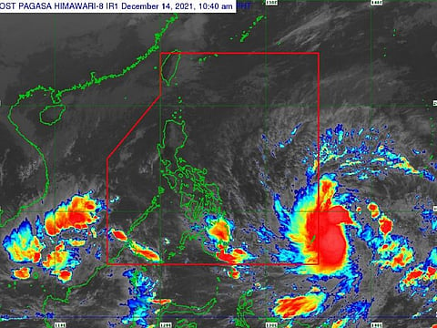
Manila: Rai has developed from a tropical depression into a severe storm on Tuesday (December 14) as it entered the Philippine’s area of responsibility (PAR) in the western Pacific Ocean.
Weathermen issued an advisory at 11am (Manila time) on Tuesday stating that “Rai” currently packs gusts of up to 115 km/h and is moving westward.
As of 8 pm (Manila), Rai’s centre is estimated at about 945 km east of the main Philippine island of Mindanao.
With a diameter bigger than the main island of Mindanao itself, Rai now packs maximum sustained winds of 95 km/h near the centre and is currently moving west-northwestward at a speed of 30 km/h.
Weathermen at the Philippine Atmospheric Geophysical Astronomical Services Administration (Pagasa) project the storm could start hammering the eastern part of the archipelago from around 8am Thursday (December 16, 2021) as it cuts through Surigao del Sur, Cebu and Palawan between December 16 to 19.
Rai is locally known as “Odette”. It is seen making landfall in the vicinity of Caraga or Eastern Visayas by Thursday (16 December) afternoon or evening.
Weathermen said atmospheric conditions will favour "sustained intensification” prior to landfall.
A pre-landfall peak intensity of around 155 km/h may be reached by Thursday morning or afternoon, Pagasa stated.
There is a high likelihood that tropical cyclone wind signals (TCWS) will be hoisted for Visayas, large portions of Mindanao, and several provinces in Southern Luzon due to the threat of strong to typhoon-force winds associated with the passage of “Rai”.
The highest possible wind signal that may be hoisted is TCWS #3.
Localities situated in the eastern portions of Visayas and Mindanao may be placed under TCWS #1 as early as Tuesday afternoon or evening.
In the next 24 hours, the Rai’s trough will bring light-to-moderate with at times heavy rains over Caraga and Davao Oriental.
The passage of this tropical cyclone over the central portion of the archipelago may bring heavy to torrential rainfall over Visayas, Mindanao, and several provinces in Southern Luzon, which may bring possible flooding and rain-induced landslides.
Warning for low-lying localities
Coastal inundation due to high waves near the coast and storm surge are also possible for low-lying localities near and along the path of the typhoon.
Residents over the northern and eastern portions of Northern Luzon and the eastern portion of Central Luzon are also advised to monitor for updates regarding possible heavy rainfall which may occur in relation to the behaviour of the "shear line” during and after the passage of this tropical cyclone.
Rai is expected to bring rough-to-high seas (reaching very high or phenomenal in open sea near the centre of the cyclone) over the seaboards of Southern Luzon and Visayas, and the northern, eastern, and western seaboards of Mindanao.


