Philippines braces for 'supertyphoon' Mangkhut
Up to 170km/h gusts from 'supertyphoon' Mangkhut approaches archipelago; low-pressure area gathers strength
MANILA: Weathermen here have advised residents to take extra precaution in the next few hours against potential flashfloods due to thurderstorms with lightning and strong winds brought about by a low-pressure area (LPA) gathering strength off Luzon's northern tip.
Spotted 200 kilometers off northern Luzon, the LPA is expected to develop into a tropical depression within 24 hours.
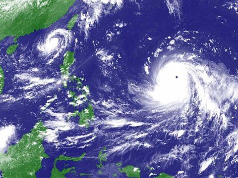
Meanwhile, a "supertyphoon" codenamed Mangkhut, packing maximum sustained winds of 140 km/h and gusts of up to 170 km/h, is set to enter the Philippines' area of responsibility by Wednesday, according to the latest bulletin issued by government weathermen.
On Monday, forecasters expect scattered rains over Ilocos, Apayao, Abra and Batanes provinces and Babuyan islands.
Meanwhile, heavy rains with lightning and strong winds due to thunderstorms are expected over Bulacan and Pampanga over the next two hours, according to a Pag-Asa bulletin issued at 7.30pm on Monday.
Bigger typhoon expected
Government meteorologist Shiela Reyes said they're keeping an eye on "supertyphoon" Mangkhut. On Monday, it was spotted 2,745 kilometers east of Southern Luzon.
It packs maximum sustained winds of 140 km/h and 170 km/h gusts, Reyes told radio DZMM.
Mangkhut is seen intensifying into a super typhoon as it moves over the Pacific Ocean, the weather bureau Pag-Asa earlier said.
The typhoon is expected to hit the US territory of Guam in the Pacific, before entering the Philippine area of responsibility on Wednesday, said Reyes.
Mangkhut is expected to pummel the Batanes and Cagayan provinces with heavy rains by Saturday. Its outer rain bands, meanwhile, will extend up to Metro Manila, the weather forecaster warned.
The supertyphoon's track may still change, so residents are urged to regularly check weather updates here.
Sign up for the Daily Briefing
Get the latest news and updates straight to your inbox


