Dubai: For those people living in the ever changing Dubai working their way around the city can sometimes be a challenge, but the task can get overwhelmingly confusing when visiting unfamiliar emirates nearby.
To simplify the process of giving directions to buildings across the country, officials at Dubai Municipality are currently working on charting all buildings across the seven emirates through its 'Makani' app.
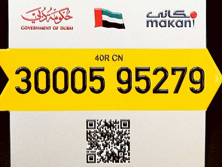
“The aim is to have all the buildings in the UAE installed with a plate, displaying the location’s 10-digit geo-coordinates,” according to Abdul Hakim Malek, director of the Geographic Information Systems (GIS) Department at Dubai Municipality.
The smart mapping system was initially launched to help the delivery-industry, in addition to first emergency responders and courier services, locate residents’ homes.
“Through launching our own app, we can enforce all participating companies to instruct their drivers to use it,” he said.
Speaking to Gulf News, Malek said that the municipality’s Makani app has already been shared with Ajman, Umm Al Quwain, Fujairah, “and the deal has just been finalised with Ras Al Khaimah.”
He explained that the process of setting up the plates in the northern emirates will not take as long as in Dubai, which was rolled out in April 2015 and continues to be installed in different phases across the city.
“Ajman will have 20,000 plates while Umm Al Quwain will receive about 7,000 plates for each building,” said Malek. “We will start focusing our efforts now on these four emirates until they are completed, and only then we will focus our efforts on Sharjah and Abu Dhabi.”
Currently, 50,000 plates have been set up in several areas, including Mirdif, Garhoud and Al Barsha, with the remaining 80,000 expected to be installed by the end of this year.
“The Makani plates in other emirates will look exactly the same but will be of a different colour. For example, the Makani bar in Dubai is yellow, while the one in Ajman will be orange,” he said.
The Makani app is accurate up to one metre of the pin selected on the map, and can also be scanned by smartphones using the QR code reader apps – providing a digital copy of the number that can be quickly shared online.
More good news is in store for taxi users, as Malek also confirmed that the Roads and Transport Authority in Dubai will integrate the Makani app into their GPS system.
“This means that customers can give their 10-digit coordinates to taxi drivers, and get to their destination without any hassle,” said.
Residents in Dubai can click here to find out when each area will be installed with Makani plates.


