Catch the progress of Expo 2020 site through satellite images
It is now possible to see how the site of Expo 2020 is taking shape
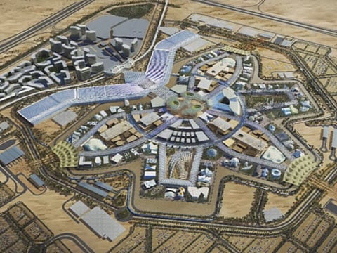
Dubai: There’s four years left to Expo 2020, and the site is just starting to shape up.
Construction formally commenced in September 2016, according to previous Gulf News reports.
And now, with the launch of new Google Map satellite images, it is possible for everyone at home to see how one of Dubai’s largest projects takes shape.
The Expo site is located on a 438-hectare parcel within Dubai South, and is expected to host over 25 million visitors during the six months of the event, which will run from October 2020 to April 2021.
The Expo’s total budget stands at Dh25 billion.
The Dh1.3 billion village project is expected to be completed by April 2018 but prior to that, construction work on the site has been divided into three sections.
The first section of infrastructure work related to the Expo, currently underway, involves work on the Expo Village, where participants will reside during the Expo period. This covers systems for sewage, water, electricity and telecom cabling.
The second section will go to tender shortly, according to a statement issued by organisers, which will include the deep infrastructure work for the gated area of the site. The third and final section will include the surface road network.
All infrastructure work is expected to finish by October 2019.
Did you know?
More than 4.7 million cubic metres of sand has been moved ahead of the main construction phase.
That is enough sand to fill about 1,800 Olympic-sized swimming pools.


