The World islands safe from the elements
Research by Emirati engineers refutes Western media claim they are eroding
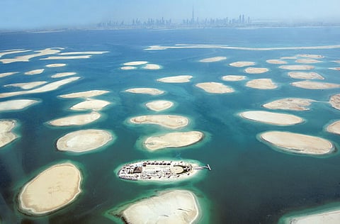
Dubai: Researchers at the Emirates Institute for Advanced Science and Technology (EIAST) claim that their research shows no erosion in The World islands, as claimed by Western media.
Two young Emirati scientists at the all-Emirati space technology institute that built and operates DubaiSat 1, EIAST, used various methods of image analysis, remote sensing and mapping to determine changes, if any, to the manmade islands off the Dubai coast.
“All signs indicate that the islands are perfectly safe and there are no signs of erosion or deterioration as claimed by some of the Western media,” said Ammar Saif Al Muhairi, Associate Research Engineer DubaiSat Programme.
Images comparied
Several reports in the Western media over the last two years have repeatedly suggested that The World island, an archipelago of 300 manmade islands combined to represent the world map, is sinking.
Al Muhairi along with Abdullah Hamad Bushahab, who is also an associate research engineer at EIAST, used DubaiSat-1 images for their analysis, that refutes the Western media’s claim.
The research compares satellite images taken over a period of 15 months and puts them through various processes like classification and change detection functions.
“Comparing the images, with classification function applied to them, shows small differences. Some of the detected changes are caused by natural phenomena, like wind, tides etc, which doesn’t mean there is an erosion or deterioration,” said Bushahab.
He said that the images showed slight differences to the shapes of some of the islands, which was due to the amount of sediment, which varies naturally.
“The changes in the levels of sediments are due to the changing water currents in the area and we haven’t noticed any specific trend that could be alarming,” added Bushahab.
Another important method that was applied in the research was the comparison between four images of the same place taken at different periods.
Change detection
“This method is called change detection. We analysed pictures that were three months old, six months old, nine months old and 12 months old to detect if there are any changes in the shape and topography of the island,” said Al Muhairi.
According to the analysis, apart from the digging activities on one of the islands and manmade connections between four islands, there were no noticeable changes.
The engineers claimed that their research results could be easily verified through field analaysis.
The images used for the research were primarily captured between November 2009 and January 2011.
However, more recent images have only confirmed their research.
.


