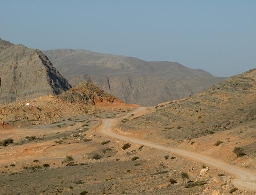
Abu Dhabi: The Masafi earthquake on March 10 last year might have caused the mountains of east Ras Al Khaimah to uplift by up to four centimetres, according to geoscientists.
Studies conducted by scientists from the Petroleum Institute in Abu Dhabi and the Japan Oil Development Company showed that the Masafi earthquake had caused the Musandam mountain area of east Ras Al Khaimah to uplift by up to four centimetres while the Musandam peninsula in the Khasab area went down by up to three centimetres, said Dr Karl Berteussen, acting director of Petroleum Geosciences Engineering at the Petroleum Institute.
"The accepted theory today is that most earthquakes take place at or near so called plate boundaries. The assumption is that the Earth's surface is separated into large plates that move relative to each other; typically with just a few centimetres per year.
"Examples of large plates are South America and Africa. We are living on the Arabian Peninsula which is one of the smaller plates. The earthquake at Masafi is believed to be connected to the movement of this Arabian Plate," Dr Berteussen said.
Using data from satellites and remote sensing techniques, scientists at the Petroleum Institute in Abu Dhabi (PI), the Japan Oil Development Company (JODCO) and JGI, a Tokyo-based company, have been trying to find out if any long-term effect of ground movements can be observed after earthquakes.
They were trying to find out whether earthquakes are just a short release of energy over some seconds and the ground afterwards goes back to where it was, or any long-term effects, which possibly fit with the theory of plate motion could take place.
Nozomi Fujita, assistant general manager of JODCO, said scientists used a technique applied in Japan and called InSAR data (Interferometric Synthetic Aperture Radar) supplied from satellites.
"During the period of the active movement in the region, an earthquake of magnitude of 4.2 was recorded in the Masafi area on March 10 2007. It is therefore possible that the uplifting and subsidence in the Musandam Mountains was caused by this earthquake.
"For the purpose of comparison, another InSAR image, recorded on September 27, 2003 was also processed to check the difference of elevation from data of February 18 2006.
"The result of this comparison clarified stable ground elevation and verified no major movement had occurred in this region for the two years and five months prior to the Masafi earthquake of March 2007," Fujita added.
To his knowledge this is the first time such data has been used in this region and the accuracy of the results are encouraging.
He added that this is just one of many examples of how satellite data and remote sensing techniques can be used.
Rapid advances in space-borne observations, coupled with intensive modelling, are revolutionising our understanding of the natural forces that might impact our society.
Together with JODCO the Petroleum Institute plans to use remote sensing data for geological studies of different kinds, said Dr Berteussen.
Have your say
Have you heard of any such phenomena? Are they a cause for concern? What do you think is a cause for such environmental activity? Tell us at letter2editor@gulfnews.com
Your comments
If the Arabian plate is pushing into Iran, then, common sense dictates that sooner or later, the man made islands will be inundated with water.
Gopal
Dubai,UAE
Posted: February 22, 2008, 11:28
I have heard such things. There is nothing to worry about it. All the mountains are formed as the Geo plates are moving. That is knowledge we have now. Why do the plates move? Nature has its own powers which we do not know until now.
Zacharia
Abu Dhabi,UAE
Posted: February 22, 2008, 07:40


