Abu Dhabi unveils online coastal atlas
System allows monitoring of marine resources
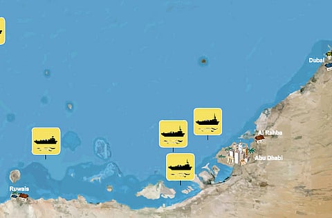
Abu Dhabi Whether it is the habitat of fishes and dugongs that interests you or whether you want to assess the impact of an oil spill, every minute detail related to the coastal environment of the emirate is now within the reach of a click, thanks to the new online coastal atlas.
Unveiled by the Environment Agency — Abu Dhabi (EAD) on Tuesday, the Coastal Resources Atlas and Vulnerability Index (‘Coastal Atlas'), is a pioneering new resource detailing Abu Dhabi's coastline and waters.
The result of two years' work, the atlas is the first comprehensive resource of its kind in the Gulf region and one of the most technologically-advanced in the world, EAD has said.
"The atlas serves as an interactive guide that will cater to a broad range of people ranging from policy-makers, scientists and coastal developers to community members," said Thabit Zahran Al Abdul Salam, director of EAD's Biodiversity Management Sector.
It is designed to aid local policy-making and coastal development planning, as well as inform and educate people interested in the emirate's rich marine biodiversity.
The atlas could be used: to find out where dugongs can be found; the kinds of fish and the different areas where they are found; to learn the impact of sea level rise; to assess density of mangroves, sea grass, coral reefs; to find locations of marine protected areas; to prepare environment impact assessments, chemical pollution and harmful algal blooms, he said. It acts as a live database and will be updated continuously.
While most of the data is available to everyone online, a second tier of the atlas is a GIS-based (geographic information system) extension that contains commercial or sensitive information. These can only be accessed by those authorised by the EAD.
"Locations of oil rigs, for example, can only be viewed by those who are granted access."
Useful tool
The atlas has been primarily designed as a tool to aid policy makers and development planners understand more about the marine environment, helping them to understand the potential impact of new policies, legislation and development decisions. It details environmental sensitivities, such as different habitats, their local biodiversity and their vulnerabilities, according to CMRECS (Coastal and Marine Resources and Ecosystem Classification System) criteria, which is internationally-recognised and considered global best practice.
"The tool will be very useful also to planners and developers who are looking at coastal settlements." For example, if they are planning to dredge, they will be able to map out sensitive areas containing high level of sedimentation and overlay these areas with ecological data. This mapping facility will provide them with data which will be beneficial in their decision-making, he said. Officials did not reveal the cost of the whole project.
The oil spill modelling application, part of the atlas, outlines potential scenarios in the event of an oil spill in the Arabian Gulf.
Based on the wind directions and current pattern, the model will help find the trajectory of the spill and point to the habitats that will be impacted.
"In Abu Dhabi, we are blessed with an abundance of natural coastline and a rich marine environment which is being increasingly recognised, such as that of Bu Tinah Island. We believe that people interested in biodiversity will enjoy learning more about our local marine habitats and wildlife through this easy-to-use online tool."
Recognition: Application wins award
The Coastal Atlas has already gained international recognition, the EAD said. The atlas received global best practice award — the Environmental Systems Research Institute (ESRI) Special Achievement Award for Geographic Information Systems (GIS) in Environmental Management for 2010. The award, which was announced about a month ago, will be presented to EAD next month, officials said.
Website
Check out the online coastal atlas at coastalatlas.ead.ae/English


