Cyclonic activity ‘expected to rise’ in Arabian Sea
North Indian Ocean basin emerges as second behind NE Pacific basin in terms of projected activity increase
A very odd atmospheric event unfolded in the Arabian Sea last week — although as with many stories involving tropical cyclones, it’s hard to say precisely how odd because records are lacking.
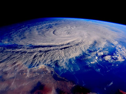
Still, here are the facts: late last week, aided by extremely and anomalously warm ocean temperatures, tropical cyclone Chapala rapidly intensified in the Arabian Sea, reaching strong category 4 intensity with maximum sustained winds estimated at 135 knots or 250 km/h, as it headed towards the Gulf of Aden and the Arabian Peninsula.
It appears to be the second strongest storm ever recorded in the Arabian Sea region, notes Colorado State University meteorologist Philip Klotzbach, at least based on reliable records that only go back to 1990.
This also made Chapala the 23rd category 4 or 5 storm in the northern hemisphere this year — a year that is vastly outdistancing the prior record of 18 in 2004.
But what was most striking about this storm is where it headed. Needless to say this is a region with very little or no experience with hurricanes. As Bob Henson of Weather Underground put it on Monday, speaking of possible effects in Al Mukalla:
It “is difficult to overstate the rarity and gravity of this event: a hurricane-strength storm striking near a large, ancient city, situated near mountains, with no modern experience in dealing with tropical cyclones. Although Hurricane Patricia got much more media attention, Chapala may end up bringing more damage and misery by far. The ongoing civil war in Yemen can only exacerbate the suffering of those affected and complicate relief efforts.”
The great fear is not only winds but very extreme rainfall in a region that doesn’t get much. As the Washington Post’s Capital Weather Gang noted of the storm Monday: “Chapala will likely bring at least five years’ worth of rain to parts of Yemen.”
So how strange is this entire event? The answer is, it’s difficult to say.
According to MIT hurricane expert Kerry Emanuel, the Arabian Sea gets tropical cyclones with some regularity (though rarely so strong). Emanuel puts it like this: “While it is unusual for Arabian Sea TCs to affect Yemen, it is not unprecedented.”
Henson and Masters found only one post-1990 tropical depression that affected Yemen in 2008 — which caused “disastrous flooding” — and two other cyclonic storms in the early 1960s. And Klotzbach, the Colorado State University meteorologist, has a map that shows seven tropical cyclones of varying strengths made landfall in the region since 1980, but almost all affecting Oman, not Yemen.
In other words, this situation appears quite rare, although precisely how rare is difficult to say, because tropical cyclone records get worse and worse the farther you go back in time.
It’s also very difficult to say whether there is any climate change connection to all of this. Clearly, the seas under the storm as it formed were quite warm, well above average - and indeed, sea temperatures in the region last month were at all time record highs, according to National Oceanic and Atmospheric Administration. But it’s unclear if this record warmth carried over into October.
Thomas Knutson, a researcher at NOAA’s Geophysical Fluid Dynamics Laboratory in Princeton, New Jersey, points out that in simulations he and his colleagues have performed to detect future hurricane and tropical cyclone changes, this is a region that sees an uptick in activity.
“Our projections for the late 21st century TC activity show the North Indian Ocean basin (Arabian Sea and Bay of Bengal both included) as second behind NE Pacific basin in terms of projected activity increase,” said Knutson by email.
But his statement comes with a big caveat: “I would caution that the confidence in such details is still very limited, especially since we don’t have clear detectable anthropogenic influence seen in observations.”
So there’s high uncertainty about how rare this really is, or how it might relate to a changing climate — or, for that matter, the current strong El Nino event. But one thing seems clear: The Yemen landfall came in a place that has little experience with such weather events, likely expected to bring stunning volumes of rainfall to a nation ravaged by war.
So in an El Nino year already featuring new levels of extreme tropical cyclone activity, the strangeness continues. And there are still two months left in 2015.

