Cyclone 'no threat to UAE'
Cyclone likely to weaken into a deep depression after reaching Oman
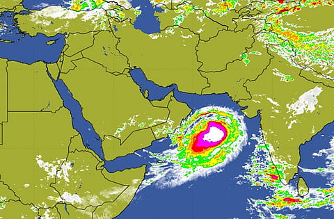
Al Ain: Tropical Cyclone 02A (Nanauk) is still 700km away from the Oman’s Masirah Island in the Arabian Sea, with no immediate threat to Oman and the UAE.
It is, however, getting stronger and moving slowly along the projected path in the north-westward direction, expected to hit the Omani coast on Sunday. Forecasters said the cyclone is likely to weaken into a deep depression after reaching Oman.
This depression, said the forecasters, will bring heavy rain along with winds of 50 to 80km/h. The surface wind will be 45-55km, according to forecasters.
People have been told not to panic as it is not yet certain whether the cyclone will hit Oman or dissipate over the sea. There will, however, be some water surge in the coastal low-lying areas along with windy conditions, said the forecasters.
The Directorate General of Air Navigation and Meteorology (DGMAN) expect heavy rain in Muscat on Saturday and Sunday. While the National Centre of Meteorology and Seismology (NCMS) said on Thursday that the weather models and charts do not show any direct effect on the UAE, at least, for the next three days.
According to the NCMS’s three day forecast, weather will be hazy and partly cloudy at times. Scattered clouds could appear in the eastern mountain areas by afternoon. Temperatures are likely to fall slightly and wind will be light to moderately rough. Sea will be rough in the Arabian Gulf and the Sea of Oman.


