Dubai: Highlighting the importance of the desalination industry in the Gulf will be the focus of the International Desalination Association's (IDA) annual summit.
Dr Farouk Al Baz, director of the Centre for Remote Sensing, Boston University, and senior advisor of Dubai Techno Park, speaks to Gulf News on rising sea levels, clean technologies and watching climate change in action thanks to satellite imagery, ahead of the IDA summit, which will open in Dubai today.
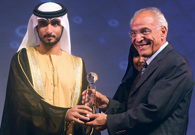
Dr Al Baz received the IDA world water masters award from Shaikh Majid Bin Mohammad Bin Rashid Al Maktoum, Chairman of Dubai Culture and Arts Authority, on Saturday.
Gulf News: How do you think the International Desalination Association (IDA) congress will help the industry progress?
Dr Farouk Al Baz: The IDA conference will highlight the importance of the desalination industry to the Gulf region and will make the various components of the desalting industry aware of the needs of the region and its aspirations.
Do you see concentrated solar power being used for desalination in the future in the UAE?
Solar energy must figure prominently in all future plans of energy generation in the Arab World in general and the Gulf region in particular. This part of the world is endowed with a rich and constant source of energy that must be fully utilised.
What are the impacts of desalination on this region and its biodiversity? Is this visible with geographic information system (GIS)?
There are two basic impacts of desalination of sea water on the Gulf environment. The first is increase of salinity of water due to the dumping of salty brine into Gulf waters. This is visible in multi-spectral satellite images as the water colour changes with salinity. The second effect is the increase of the temperature at the brine dumping sites. This is also visible in the thermal images from space that record variations in temperature.
Putting such data along with others in a geographic information system allows the detection of the affected areas to undertake measures to alleviate the resulting problems.
Do you think clean technologies need something like Techno Park as an incentive to base themselves in the UAE?
There is no question that clean energy requires scientific and technological research. The best vehicle for such research is a compound where a group of researchers can conduct the necessary experimentation. Worldwide, we have seen such activities flourish at Techno Parks. Thus, Dubai Techno Park provides an incentive for such industrial, research and educational entities to base their work in the UAE.
To what extent can GIS show the impacts of climate change in the Middle East?
Satellite images are ideal for monitoring any changes. This includes urban development, vegetation patterns, coastal changes, etc. One image taken at a given time is compared to another taken at a later time and the special computing programmes provide the change between the two. Thus climate changes can be monitored with great accuracy.
How fast has the rate of depletion been in this part of the world?
The rate of resource depletion in our region has not been great or alarming. The region is still sparsely populated in comparison with others, and there is not a huge pressure on resources except fresh water.
In regards to the Arab Forum for Environment and Development (AFED) annual conference being held in Beirut in a few weeks, and its 2008 report, "Arab Environment: Future Challenges" — how was this received in the Arab world, and what will you present at this meeting?
The AFED annual conference has received much attention in the Arab World. This is a sign that issues of environmental preservation are now prominent in most Arab circles, both at the level of governments and non-governmental organisations.
My presentation is entitled: "When the Desert Was Green". It deals with major natural climate change that caused the formation of the desert by dryness. Some Arab deserts represent the driest region on Earth, where solar radiation is capable of evaporating 200 times the rainfall. The hyper-aridity forces inhabitants to depend on groundwater.
However, geo-archaeological data indicate that they hosted wetter climates in the past. At least five palaeo lake-forming episodes took place prior to 350,000 years ago. Each episode roughly correlates with an interglacial period.
Space image data indicate that sand in inland basins of the desert was transported there in river channels during past rainy periods. Some of the surface water seeped into the underlying porous rock to accumulate as groundwater aquifers. During dry conditions, wind formed sand dunes and sheets atop these basins. Examples are given in southwest Egypt and North Darfur.
In Egypt, space data allowed mapping the "East Uweinat" basin, where 540 wells were drilled to water many crops. The proven water resources are capable of supporting agriculture over 150,000 acres for 100 years. In North Darfur boundaries of a similar dry lake were revealed by radar images and topographic data. This basin is being investigated by the United Nations for its groundwater potential.
What are the elements of the report being carried out at the Centre of Remote Sensing at Boston University (CRS-BU), which uses satellite images to analyse the impact of climate change on Arab countries?
This part of the report deals with modelling of the effects of the rise of temperature on sea level rise along coastal regions of the Arab World. Naturally, the effects would be most severe along low elevation coastal regions such as the Nile Delta coast along the Mediterranean Sea.
Ahead of the United Nations Climate Change Conference in Copenhagen in December, what do you think should be the agenda of the Arab world?
I do not know what is being prepared by our political entities in regards to this meeting. However, we can assume that the Arab countries will present a position that includes the effects on coastal areas. We also can assume that Masdar will be prominently represented as it is one of our major initiatives.
Can you highlight some of the worse climate change impacts that will be felt in the Arab World?
The grievous effects of sea level rise will be on low coastal topography. In general this includes the northern part of Nile Delta, the low areas along the Arabian Gulf coast of the UAE, and parts of the coastal region of Mauritania.
Is there still time for action to be taken?
We are not too late to start and we should join the rest of the world in making the necessary measurements of our environment and its changes over time. This is necessary to allow us to prepare for the future.
Egyptian-American scientist who worked on the Moon Mission
Dr Farouk Al Baz is an Egyptian-American scientist who worked with Nasa to assist in the planning of scientific exploration of the moon, including the selection of landing sites for the Apollo missions and the training of astronauts in lunar observations and photography.
Currently, Dr Al Baz is a Research Professor and Director of the Centre for Remote Sensing at Boston University.
He is Adjunct Professor of Geology at the Faculty of Science, Ain Shams University, Cairo, Egypt. He is also a member of the board of the Geological Society of America Foundation, Boulder, Colorado, and a member of the US National Academy of Engineering, Washington, DC.
He was born on January 2, 1938, in the Nile Delta town of Zagazig. At the age of 20, he received a BSc in Chemistry and Geology from Ain Shams University. In 1961, he received an MS degree in Geology from the Missouri School of Mines and Metallurgy (now Missouri University of Science and Technology). In 1964 he received a PhD in Geology from the Missouri University of Science and after conducting research in 1962-1963 at the Massachusetts Institute of Technology, Cambridge. In 1989, he received an Honorary Doctor of Science degree from the New England College, Henniker, New Hampshire; in 2002 a Professional Degree from Missouri S&T; in 2003 an Honorary PhD from Mansoura University in Egypt; in 2004 a Doctor of Laws degree from the American University in Cairo; and in 2004 an Honorary Doctor of Engineering degree from Missouri.
Source: http://faroukelbaz.com
Agenda: Assessing impact
The International Desalination Association (IDA) World Congress on Desalination and Water Reuse will be held from today to November 12 at Atlantis, The Palm, under the theme ‘Desalination for a Better World'.
The Congress will address environmental and energy impacts of desalination on the global stage by exploring the challenges, trends and advances in the industry, as a reflection of the aim of both IDA and the industry to make desalination and water reuse sustainable and affordable.


