Powerful Cyclone Phet barrels toward Oman
Cyclone Phet barrelled towards the coast of the Oman
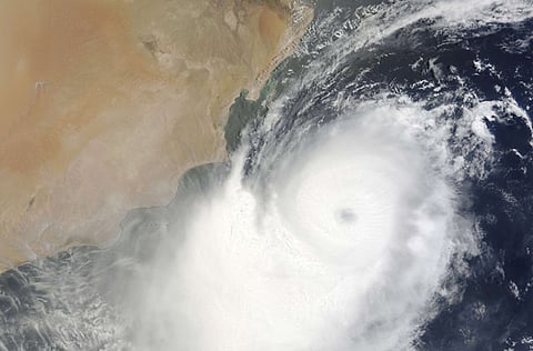
Muscat: Tropical Cyclone Phet barrelled towards the coast of the Gulf Arab state of Oman on Wednesday, strengthening fast and forecast to become a powerful Category 5 storm.
Phet is expected to reach Oman in 30 to 36 hours, said Professor Mark Saunders, lead scientist and project manager at Tropical Storm Risk, a University College of London department.
"It will strike land as a super cyclonic storm with a speed of over 130 miles (210 km) per hour, and either Category 4 or 5," Saunders told Reuters by telephone.
A storm that powerful would be strong enough to damage buildings, pull down trees and damage infrastructure, he said.
State television said the government had ordered police and the air force to evacuate people from eastern Oman, where waves were 8 metres (26 feet) high. National carrier Oman Air said it had cancelled two flights so that aircraft could evacuate people from Masirah island off the east coast.
The storm is stronger than Cyclone Gomu, which killed at least 54 people in Oman and Iran in 2007, Saunders said.
Phet will move inland over eastern Oman before re-emerging over the north Indian Ocean and roaring on to Pakistan, according to Tropical Storm Risk forecasts shown on website www.tropicalstormrisk.com.
The cyclone will steer east of the Gulf and the Strait of Hormuz, used by ships carrying 17 million barrels per day (bpd) of oil, 40 percent of all seaborne oil, and may disrupt shipping moving from the Gulf towards the Indian Ocean.
Phet strengthened to a Category 4 storm earlier in the day, with sustained winds of over 143 mph. It was expected to become a Category 5 storm, the most powerful category with winds of over 156 mph, in the next 12 hours.
It will move through eastern Oman on Friday and then head northeast, probably weakening to a tropical storm before coming ashore again near Ormara in Pakistan on Sunday.
Most Omani oil exports move from Mina Al Fahal port near the capital Muscat. The storm should turn northeast before reaching Muscat, but hurricane-strength winds are likely in the capital.
Operations at Oman LNG, the liquefied natural gas export facility, are so far unaffected, "but we are in touch with the authorities to see if there will be any change," Nasser al-Kindy, head of Oman LNG corporate communications, told Reuters.
The three LNG production facilities, known as trains, are in Sur in the east, close to the path of the storm. They produce about 8 million tonnes per year of LNG.
The east is also home to Oman's protected green back turtle.


