Cyclone Chapala hits Yemen
At least 20 homes damaged, up to 9,000 people take refuge in schools; up to 390,000 people could be affected
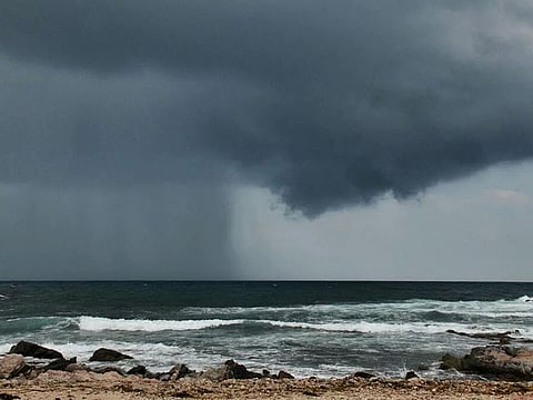
Muscat, Aden: Cyclone Chapala unleashed its fury today (Monday) as it is slowly moved towards the southern coasts of Oman and Yemen.
The name Chapala was suggested by Bangladesh. It is a girls’ name, meaning "restless".
In Muscat, the National Centre for the Early Warnings ruled out, however, that the Chapala Cyclone will make a landfall on the southern coasts of Oman or has direct influence on Dhofar coasts. The centre said that the Chapala swerved off to the west towards the Yemeni coats.
In Sultan Qaboos, who will turn 75 this month, oversaw the measures taken by his country with the approach of cyclone Chapala, according to the official ONA news agency.
More than 5,000 persons were put in 21 shelter centres across in Dhofar, as a precaution against possible flooding of the low-lying residential areas. Heavy rainfall and strong winds brought by Chapala are expected to lash Dhofar and Wusta from Monday.
Socotra island lashed
On the island of Socotra, off Yemen, however, trees have been uprooted and fishing boats sank while officials officials said the cyclone had seriously damaged or destroyed at least 20 homes.
They said many residents living near the coast are taking shelter in caves or in schools. The island is being hit by heavy rain and strong winds, and rising waves are battering the coast. The officials said coastal areas are flooded.
Authorities on the island have transported 9,000 people from their homes to other places to take refuge, mainly schools, said Socotra Deputy Governor Ramzi Mahfouz.
But the evacuation was only carried out in the provincial capital, Hadibo, and residents elsewhere are facing more challenges.
Fuel shortage
The situation is being compounded by a shortage of fuel on the island for more than 20 days, he said.
Mohammed Salmein, a resident of the island, said they haven't seen winds and rain like this in decades.
"We are expecting a true disaster to befall us," he said, "and only God knows whether we will last until tomorrow."
Socotra island lies in the Indian Ocean some 230 miles (368 kilometers) off the coast of Yemen's mainland. It is known for its unique vegetation and ecosystems, including rare dragon blood trees.
The U.N. weather agency said Friday that Cyclone Chapala could dump more than a year's worth of rainfall on the arid, impoverished and war-torn country.
The Global Disaster Alert and Coordination System forecasts the storm will make landfall in Yemen around mid-day Tuesday, following earlier estimates that it would hit on Monday.
It said that up to 390,000 people could be affected by the wind speeds, and 3,500 people residing in coastal areas could be affected by storm surge.
In Al-Mahra, Yemen's easternmost province, security officials said dark clouds are forming amid unusually strong winds, though no damage has been reported yet.
Neighbouring province Hadramawt, which is partially controlled by Al-Qaida, is also bracing for the storm. The Emergency Council in Hadramawt, which is supportive of exiled President Abed Rabbo Mansour Hadi, appealed to citizens living in coastal areas to evacuate their homes and move to high ground.
Mukalla, a city under Al-Qaida control, is evacuating a coastal neighbourhood which is one of the oldest in the city.
All officials spoke on condition of anonymity because they were not authorised to speak to journalists.
Heavy rains
Socotra island lies in the Indian Ocean some 230 miles (368 kilometers) off the coast of Yemen's mainland. It is known for its unique vegetation and ecosystems, including rare dragon blood trees.
The U.N. weather agency said Friday that Cyclone Chapala could dump more than a year's worth of rainfall on the arid, impoverished and war-torn country.
The Global Disaster Alert and Coordination System forecasts the storm will make landfall in Yemen around midday Tuesday, following earlier estimates that it would hit on Monday. It said that up to 390,000 people could be affected by the wind speeds, and 3,500 people residing in coastal areas could be affected by storm surge.
In al-Mahra, Yemen's easternmost province, security officials said dark clouds are forming amid unusually strong winds, though no damage has been reported yet.
Neighboring province Hadramawt, which is partially controlled by al-Qaida, is also bracing for the storm. The Emergency Council in Hadramawt, which is supportive of exiled President Abed Rabbo Mansour Hadi, appealed to citizens living in coastal areas to evacuate their homes and move to high ground.
Mukalla, a city under al-Qaida control, is evacuating a coastal neighborhood which is one of the oldest in the city.
All officials spoke on condition of anonymity because they were not authorized to speak to journalists.
Weakening
On Sunday, the storm’s classification dropped from a category 3 level to category 2 with wind speed dropping from 105 knots to 85 knots.
The weakening of the storm comes as a relief to residents who have been bracing for one of the worst storms in recent years. Mohammad Al Hadi, an official at the Directorate General of Meteorology, told Gulf News the cyclone would further weaken to category 1 before it makes landfall.
In Oman, residents in the southern governorates of Salalah, Sadah, Rakyoot, Dalkoot, Shleem and Halanyat island are on alert.
Many people living in low altitude areas have evacuated. Many Omanis have opened their homes for those in need.
Torrential rains are expected to continue from Monday to Tuesday and rough sea waves could reach up to seven metres high.
All Omani forces are on high alert as they have deployed to different areas in Dhofar and Wusta governorates to provide any needed assistance and emergency services.
Civil defence vehicles, boats and rescue equipment are on every corner of Dhofar governorate and mobile stations are ready to provide electricity to main hospitals like Sultan Qaboos hospital in Salalah, in case of any outage.
Royal Oman Police are stationed near wadis to make sure people do not cross, as many have died in the past after flood waters have swept away their cars.
Ahmad Tabook, a resident of Qiruw Hiriti, told Gulf News that there are over 10 furnished houses open for displaced residents of Rakhyoot province. He said his village is ready to provide meals for the next three days.
Omanis rushed to social media to praise those Omanis who are helping other families during the storm and urged others to follow their example.
Around 450 residents of Al Halanyat island were evacuated due to its extremely low altitude.
Authorities in Dhofar have allocated more than 21 shelters for those displaced.
Meanwhile, Omanis have launched a campaign nationwide to help Dhofari people by providing them with food supplies, water, blankets and beds.
Volunteer teams will arrive in Dhofar and Wusta on Wednesday and Thursday to assist authorities in the clean up.
UAE spared
The UAE will be spared from any direct damage from the storm, according to UAE weather forecasters.
Coastal areas of Yemen were to bear the brunt of the tropical storm which was expected to weaken in strength before it was forecast to hit landfall on Monday at 1 am, said weather officials.
The National Centre of Meteorology and Seismology in the nation’s capital said that around 11 am on Sunday, the storm was “located about 410 kilometres south-southeast of Salalah in Oman and about 210km northeast of Socotra Island in Yemen.”
The weather centre said the storm was moving at a speed of about 15 km/h and that its ranking as an “extremely severe cyclonic storm” was forecast to be downgraded.
Forecasters said the storm “would move nearly westwards during next 24 hours, then west-northwest and cross Yemen coast as a very severe cyclonic storm near Latitude 15.0 degrees North at 1am local time on Monday morning, associated with a broken low and medium clouds with embedded intense to very intense convection.”
According to the World Meteorological Organisation (WMO) a very severe cyclonic storm has a maximum sustained surface wind speed of between 150-160 km/h with gusts of up to 175 km/h.
WMO’s Regional Specialized Meteorological Centre, based in New Delhi, earlier described Chapala as an extremely severe cyclonic storm and predicted that “the system is expected to weaken to the equivalent of a category 1 or 2 hurricane, with wind speeds of between 150 and 160 km/h before it makes landfall. The area where the cyclone is expected to make landfall is fairly sparsely populated. Most of Yemen’s infrastructure like ports, roads and cities, is concentrated in the southwest.”
The WMO said in a statement that “the most serious impacts are expected from the very heavy anticipated rainfall ... the region is climatically very arid. There is a fear that the storm will trigger significant flooding and related severe impacts such as mudslides, and infrastructural damages. The forecast rainfall would represent an extremely unusual event for the area and it is highly unlikely that the natural water courses and drainage systems would be able to cope with this amount of rain. Moreover, since cyclones in this area are extremely unusual, it’s highly likely that strong to gale force winds will also have a significant impact, particularly offshore and in coastal areas.”


