Dubai buildings to be assigned precise map coordinates
News system ensures better response to emergency situations
Dubai: In a new municipal address system that resembles US zip codes, buildings will be assigned precise map coordinates to help police and civil defence authorities respond to exact locations within minutes.
The civic body will start rolling out its first phase of the address system in May, and will start distributing building mapping coordinates to residents, commercial shops and restaurants, said a senior municipal official on Monday.
“The project itself is finished and we are in the final auditing phase of recording the coordinates of all 130,000 buildings,” said Abdul Hakim Abdul Kareem Malek, Director of Geographic Information System at Dubai Municipality.
Speaking on the sidelines of the two-day Urban Agenda 2020 Conference at the Outdoor Design, Build and Supply Exhibition, Malik explained that the coordinate system is part of the municipality’s Smart Geo Addressing System.
Dubai Municipality’s plan to set up plates on households and commercial outlets has been put on hold, as it waits for approval from the Federal National Council. Once the project is given the green light, the plates are expected to serve residents and businesses in all the emirates.
In the meantime, Malek told Gulf News that it has not postponed its Smart Geo Addressing System, and will instead distribute the coordinates to residential and commercial buildings.
“Once the system is approved, it will cost Dubai about Dh5 million to set up the plates over one year’s time. We have to be practical and think practical…so when somebody on the street calls 999, and they do not have a smartphone, they will be able to see the plate on the lamp post or bus station, and report the location of the accident or the crime,” said Malek, who added that the authority aims to integrate the habit of the new address system among residents before 2020.
“But while we are waiting for the final decision, we will do something temporary and distribute the coordinates within six to eight months across the city and Hatta,” he said.
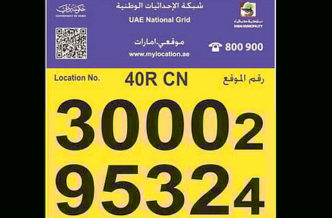
The geographic coordinates will be distributed in the form of small cards accompanied with a brochure, informing the public on how the system benefits them, and how it can be used.
Buildings can be pinpointed at Dubai Municipality’s Makani application, which is now available in Arabic and English on Android and iPhones. Since March 10, the application has been downloaded more than 1,000 times, and enables the user to retrieve their own unique identifier comprising 10 digits.
“We are now thinking of what is the best way to give the numbers to people in apartments, as there can be 100 apartments in a building. But that plan will be carried out at a later date,” he said.


