India, US mark historic milestone with successful launch of NISAR satellite
Landmark NASA-ISRO mission to transform Earth observation and disaster prediction
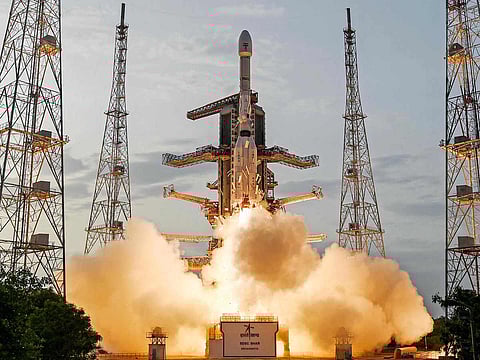
In a major leap for Indo-US space cooperation, the NASA-ISRO Synthetic Aperture Radar (NISAR) satellite was successfully launched on Wednesday aboard India’s GSLV-F16 rocket. The launch took place at 5:40pm IST from the Satish Dhawan Space Centre in Sriharikota, Andhra Pradesh.
“We have liftoff! GSLV-F16 has successfully launched with NISAR onboard,” announced the Indian Space Research Organisation (ISRO) in a post on X.
NISAR represents the first collaborative Earth observation mission between ISRO and the US space agency NASA, combining their technical expertise to track changes in the Earth’s land and ice surfaces with unprecedented accuracy.
Satellite to monitor Earth’s changing landscape
The NISAR mission is valued at approximately $1.5 billion and is designed to observe even minute deformations — less than one centimetre — in the Earth's surface. These measurements are crucial for early detection of natural hazards like earthquakes, landslides, volcanic eruptions, and human-induced threats such as the degradation of ageing infrastructure like bridges and dams.
“Go NISAR! The joint NASA-India satellite aboard @ISRO's Geosynchronous Launch Vehicle launched from the southeast Indian coast at 8:10am ET on its mission to monitor Earth's changing land and ice surfaces,” posted NASA on X.
India, in particular, aims to use NISAR’s data to study coastal changes, the evolution of sea floor topography near river deltas, and shoreline erosion or expansion. The mission will also provide valuable data for agriculture by tracking crop growth, plant health, and soil moisture levels.
24x7 high-resolution imaging in all conditions
Weighing 2,392 kilograms, the NISAR satellite has been placed in a sun-synchronous orbit at an altitude of 740 kilometres. It will survey the Earth’s landmass and ice-covered regions every 12 days, delivering high-resolution radar images across a 242-kilometre swath using SweepSAR technology — being deployed for the first time in space.
“It can take images 24 hours a day, regardless of weather conditions,” said ISRO Chairman Dr V. Narayanan. “The satellite will play a vital role in detecting landslides, improving disaster response, and tracking the effects of climate change.”
A symbol of strengthening US-India space ties
The launch of NISAR underscores the strengthening of civil space cooperation between India and the United States. Following a high-level summit between Prime Minister Narendra Modi and US President Donald Trump, both nations declared 2025 a milestone year for bilateral space collaboration.
Notably, NISAR is the first satellite to feature dual-frequency Synthetic Aperture Radar. It operates using both L-band and S-band frequencies, allowing it to distinguish between taller vegetation such as trees and shorter foliage like shrubs, enabling comprehensive ecological monitoring.
The spacecraft was jointly developed by NASA’s Jet Propulsion Laboratory (JPL) and ISRO. While NASA contributed nearly $1.2 billion towards the project, ISRO’s share stood at around $90 million. Final assembly and testing were carried out at ISRO’s Satellite Integration and Testing Establishment in Bengaluru.
NISAR’s launch not only advances scientific understanding but also cements a new era of space partnership between India and the US.
— With inputs from agencies


