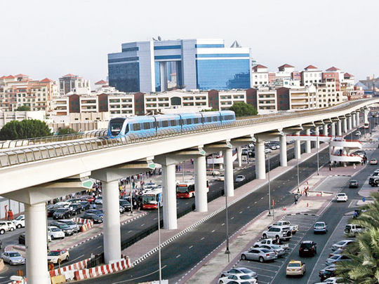
DUBAI: Come September - September 9 to be precise - and the journey between old and new Dubai will be just a few brisk steps away.
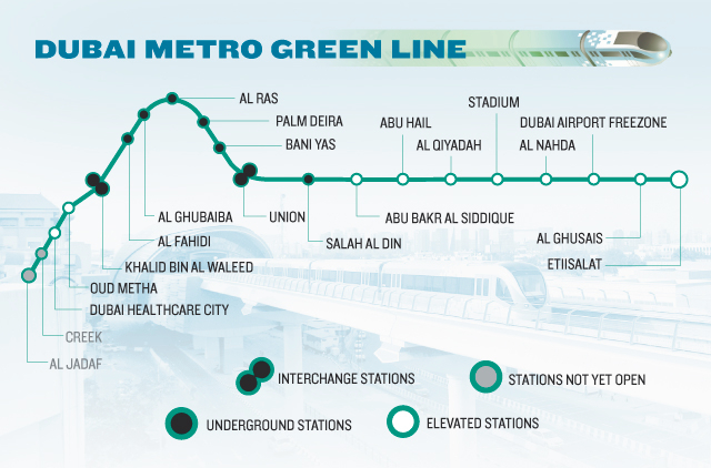
The Green Line starting that day will snake into the farthest nooks and crannies of Dubai, while linking most government buildings to the rest of Dubai.
During peak hours, 14 trains will run at six- to eight-minute intervals.
With the new line traversing Dubai's residential, business, diplomatic, cultural and health centres, parking woes and narrow roads chock-a-block with traffic could be a thing of the past.
Eight kilometres of the 23-km line are underground, a five-year engineering job seen to shore up Dubai's status as a tourism, trading and service hub.
The Green Line thus brings to completion the ambitious Dh28-billion Dubai Metro project, which together will have 50 trains running at peak hours (28 trains at off-peak).
The highly successful Red Line, launched in September 2009 with up to 180,000 daily users, has already changed the city's transport landscape. While the Red Line connects homes and high-rises to two airport terminals, the Green Line connects the two old quarters on either side of Dubai Creek, with Al Ras and Al Ghubaiba stations clad in traditional Emirati architecture dovetailing three modes of transportation -- train, bus and Abra.
People from Sharjah and other emirates can opt to use the park-and-ride terminal that can hold 2,350 vehicles at etisalat station to explore the rest of the city.
XPRESS visited the 18 stations opening on the Green Line to give you the lowdown on the areas they serve and the prominent landmarks near each stop.
Happy travelling.
18 new stations, 18 areas to discover
Dubai Healthcare City Station
What's around: Specialised clinics and medical centres of international repute offering western, ayurvedic and homeopathic practices and some malls.
Walking distance from station (in minutes): Dubai Healthcare City (2-10), City Hospital (2), Dewa headquarters (5), Wafi Mall (5), Grand Hyatt Hotel/Grand Cineplex (6), and Citibank (6), Canadian Specialist Clinic (14), American Hospital (15).
Oud Metha station
What's around: A number of cultural and health centres. The neighbourhood encompasses sports clubs and borders a number of churches belonging to various denominations, mosques and private schools, Dubai TV and a number of residential districts.
Walking distance: Rashid Hospital (3) Al Nasr Sports Club (5), Pakistan Education Academy (5), Indian High School (5), cultural clubs - Iranian, Jordanian, Pakistani, Egyptian, Sudanese (6-12), Churches: St Marys/Orthodox/Holy Trinity (6-12), Norwegian Seamen's Centre (8).
Khalid bin Al Waleed station
What's around: Second intersection between Red and Green Lines. The station is close to commercial outlets and populated areas of Bur Dubai and Al Karama.
Walking distance: Consulates/embassies (Saudi, Libya, Kuwait, India, Pakistan, Oman, Sudan, Yemen, Egypt, Lebanon, Jordan, UK, Canada, Holland, America - (3-12), BurJuman Mall (2), high-end shopping outlets, dining outlets (2-10).
Al Fahidi station
What's around: Historical sites and hotels. This is where Khalid bin Al Waleed Street meets with Al Musalla Road. This is the heart of ‘Computer Street', a.k.a. ‘Bank Street', where numerous IT shops sit next to banks.
Walking distance: Musalla Tower (2), Al Ain Centre (3), Meena Bazaar (12), Al Bastakiya heritage village (9), Dubai Museum (10) and night spots and hotels in Bur Dubai (2-10).
Al Ghubaiba station
What's around: A transit point between the Metro, bus and marine transport services, this station is located in one of the busiest districts of Bur Dubai near Al Bastakiya and Shindagha, Dubai's key heritage sites. This is expected to be a crowd and tourist-puller, particularly during the Dubai Shopping Festival, a perfect venue for staging cultural events.
Walking distance: Golden Cinema (2), Shindagha Heritage and Diving Village (3), Carrefour (2), Al Ghubaiba Bus terminal (2) and Marine Station (4), Al Rifaa Police Station (5), Old Souq (5-7).
Al Ras station
What's around: Wholesale and retail outlets, gold and carpet shops, historical buildings such as Al Ahmadiya School, the first school built in the emirate.
Walking distance: Gold Souq (3), Public Library (2), Gold Souq Bus Station (4), Spice Souq (5), Al Ahmadiya School (5).
The Palm Deira station
What's around: The station's proximity to the sea and the Old Souq makes it a big draw for tourists and residents looking to combine retail shopping with a stroll by the sea.
Walking distance: Deira Corniche (3), Hyatt Regency Hotel (3), Deira Old Souq (3), Fish Market (3).
Bani Yas station
What's around: Discount shops are a magnet for bargain hunters here. Close to the old business centre of Dubai and Abras plying the Creek. A shopping complex for Chinese goods is next to Naif Souq. Shops selling leather goods, mobile phones, car accessories, electronics, fabrics, souvenirs.
Walking distance: Baniyas Square (1), Choithrams (1), Deira Tower (1), Downtown Medical Polyclinic (2), Naif Souq (3)
Union Square Station
What's around: The heart of old Dubai, with commercial outlets along Al Maktoum Street.
It's the world's largest underground Metro station at 25,000 square metres, linking the Red and Green Lines.
Walking distance: Dubai Municipality (2-3), Dubai Chamber of Commerce and Industry/Lands Department (5-7), Radisson Blu Hotel (3).
Salah Al Din station
What's around: A central business district with a wide choice of gourmet outlets, hotel apartments and music stores. A prominent tourist destination, this unique location is expected to be popular for Metro commuters.
Walking distance: Al Reef Mall (2), Al Ghurair Centre (5), Fish Roundabout (5), Music stores (5-10).
Abu Bakr siddique station
What's around: Surrounded by commercial areas, a residential neighbourhood, building material showrooms, an industrial area, auto repair shops, warehouses and hotels
Walking distance: Hamrain and Warba Centres (3), Al Muraqqabat Police Station (3), Caterpillar dealership (4), Traders Hotel (2), Movenpick Hotel (4-5).
Abu Hail station
What's around: Offers integrated transit services with the nearby bus station fitted with a waiting area for passengers.
Walking distance: Abu Hail Centre (6), Sana Fashions (4), Ministry of Environment and Water (4), Canadian Specialist Hospital (5), Omar Bin Al Khattab Model School (5), Al Huda Kindergarten (7).
Al Qiyadah station
What's around: Expected to be hugely popular with individuals, including visitors. Close to Dubai Police HQ. An air-conditioned walkway links it with the other side of Al Ittihad Road to serve passengers heading towards commercial centres in the area.
Walking distance: Dubai Police General HQ (2-3), Al Mamzar Centre (3), Atrium (2), Peugeot showroom (8).
Stadium station
What's around: Housing complexes next to commercial and sports facilities
Walking distance: Lulu Center (2), Handicapped Club (2), Al Ahli Club (3), Dubai Club for Special Sports, (4) Al Mulla Plaza (5), DM Housing complex (5), Dubai Youth Hostel (5).
Al Nahda station
What's around: Medium-rise residential area with shopping malls and community schools.
Walking distance: Al Bustan Center (2), Al Ghusais Mosque (3), Splash (3), Dubai National School (7), Emirates Driving Institute (10), Ministry of Labour/Ministry of Social Affairs Building (20-25).
Dubai Airport FreeZone station
What's around: A highly populated residential area dotted by low-rise residential buildings with its share of shopping, hotels and restaurants.
Walking distance: Shop 'n' Save (2), Karachi Darbar (2), Zulekha Medical Centre (3), Al Twar Park (3), Falah Primary School (4), Union Coop (5), Al Twar Public Library (6), Dubai Airport Free Zone gate (18-20).
Al Ghusais Station
What's around: Residential area and several key government buildings. The station is close to Beirut Street, which directly connects with industrial areas in Al Ghusais and Sharjah.
Walking distance: Ministry of Education (2), Ministry of Public Works (3), Dubai Civil Defence HQ (5), Al Ghusais Police Station (6), DM Customer Services Ctr. (4), Al Twar Center that houses Dubai Chamber, RTA, Department of Economic Development, Dubai Courts, Ministry of Labour office (2).
Etisalat Station
What's around: The Green Line starts here, just off Emirates Road. The station is expected to attract users from nearby communities as well as Sharjah and other emirates. A multi-level park-and-ride complex for over 2,350 spaces is linked by air-conditioned footbridges to the Metro terminal and a bus station nearby.
Walking distance: Park-and-Ride Terminal (1-3), Al Twar 3 Park (8), Al Rahif Medical Clinic (4), Emirates Coop Society supermarket (5).
18 out of the 20 stations will open on Sept 9
Timings extended
RTA has extended the Dubai Metro operating hours from 11pm to midnight on weekdays (Saturday to Wednesday), and from midnight to 1 am on weekends (Thursday and Friday), starting September 3, 2011.
The Green Line will follow the same timetable from September 9.
Green line in numbers
- 2,350: the number of park-and-ride slots at etisalat station
- 4.10: Dirhams, the maximum fare on the Green Line per trip (as it passes two zones)
- 5.8: Dirhams, the maximum fare if the Green Line is used in conjunction with a bus and three or more zones are crossed.
Dubai Creek Crossings
- 1963: Maktoum bridge
- 1975: Shindagha Tunnel
- 1976: Old Garhoud Bridge
- 2007: Floating Bridge
- 2007: Business Bay Bridge
- 2008: New Garhoud Bridge
- 2009: Red Line2011: Green Line


