The coolest driving routes in the UAE
Since it’s Wrangler season, we’ve picked four of the best routes, tarmac and offroad
Route 1
The route: Go coast to coast. Start in Dubai and drive all the way to Kalba on the east coast, via a twisty mountain road near Hatta, and then on to the beautiful Sharjah-Kalba road ensconced in the comfort of the Jeep
Grand Cherokee.
Starting point: The Jeep Showroom at Dubai Festival City.
Directions: Set your trip meter to zero, get on the Dubai-Al Ain road (E66) and then take the exit to Hatta/ Oman (Exit 30). Once on the Dubai-Hatta highway (E44), drive toward Hatta. Keep your National IDs or passports handy because you will encounter a military checkpoint at the border of a swathe of land (Buraimi) in Oman, before you reach the Hatta roundabout.
Go straight on from the roundabout and, in less than a kilometre (your trip meter should be around 110km now), turn left at a road sign that says Al Huwaylat.
You are now looking at about 10km of twisty dual carriageway here. The mountain bends are challenging, fast and exciting. At the end of this stretch, you will hit a roundabout (GPS co-ordinates: N24° 53’ 6.07”, E56° 10’ 11.10”). Turn left and drive northwest for about 8.9km until you reach another roundabout. Take the first exit to join the Sharjah-Kalba (E102) road.
This stretch snakes its way through the Hajar Mountains, even passing through a tunnel. At 1.27km long, this is the longest tunnel in the Gulf.
As you descend into Kalba, take in the glorious views of the Gulf of Oman. From Khor Kalba – a mangrove forest and a popular site for bird watching – you can either drive back the same way or drive on 20km north toward Fujairah, before joining the Shaikh Khalifa Freeway (Fujairah City Centre is your nearest landmark), and then take the Dubai-Sharjah bypass to find your way back home.
Distance: 330km (the entire loop)
Route 2
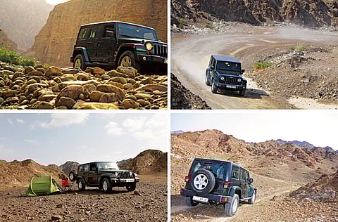
The route: The rocky trails of Ras Al Khaimah’s Shawka region in a Jeep Wrangler
Starting point: The Jeep Showroom at Dubai Festival City.
Directions: Set your trip meter to zero, get on the Dubai-Al Ain road (E66) and then take the exit to Hatta/ Oman (Exit 30). Turn at Exit 24 and join the Dubai Bypass road.
Drive for 21km until you join the Maliha Road that leads to Kalba. Stay in the right lane until you spot an Emarat petrol station. It is not unusual to find 4x4 groups or bikers who congregate here to stock up on supplies before heading out in the open. Fill up your tank here if you haven’t already.
About 3km from the petrol station, drive for about 50km on the Maliha road, past the giant coffee pot, until you spot the Shawka/Manama Exit. From the roundabout, take the first exit (right) and go straight until you reach the T junction. Take a left and drive
1km until you reach another roundabout.
The road ends here; your GPS will also indicate the end of your route.
From here, take the second exit and drive another 2km up a dirt road until you reach a clearing. This is a good place to set up camp (25° 1’ 55.82”, 56° 1’ 36.46”).
From here, you can explore the off-road trails around this area, and there are plenty of them. You will chance upon many wadis, a few dams and rock formations that the Wrangler will enjoy climbing. The best part is that you’ll hardly see another soul, apart from the occasional local farmer. Be advised that this place will flood quickly when it rains, so check the weather forecast before you head out.
Distance: 90km (one-way)
Route 3
The route: Explore a rocky off-road trail in Wadi Wurrayah, a canyon located deep within the Hajar Mountains just off the East coast. The trail is about 3km and is a good beginner’s trail for rookie off-roaders.
Starting point: The Jeep showroom at Dubai Festival City.
Directions: Follow the Nad Al Hammar road that links up with Emirates Road (E311). Drive for about 10km until you hit the National Paints Roundabout in Sharjah. Turn right on to the Maliha Road and then head east until you join the Sharjah-Kalba road. Follow this for about 125km (from the National Paints roundabout) and you will meet the E99 highway in Khor Kalba.
From here, drive north toward Khor Fakkan. You are about 60km from Wadi Wurrayah now. This stretch can be quite dreary, but be patient and you’ll be rewarded. Once in Khor Fakkan, drive north toward Dibba from the Oceanic Hotel. Drive past three roundabouts, make a U-turn and drive back about 700m, before making a right. Follow this road away from the coast and toward the mountains in a south-westerly direction.
Wadi Wurrayah’s high canyon walls, rocky outcrops, streams and waterfalls are unlike the rest of the of the country. The UAE’s first protected mountain area, Wadi Wurrayah’s unique hydro-geological system has helped create freshwater streams, pools and waterfalls in an otherwise arid region.
The area around the waterfall can get busy on the weekends, so follow the off-road trail in the Wadi (GPS co-ordinates: N25º 23’ 15”, E56º 15’ 56”) for about 3km. Progress is slow on the rocky trail, but the Wrangler is in its natural habitat. In 4WD mode, the trail is conquered with consummate ease.
Total distance: 165km (one-way only)
Route 4
The route: Dubai to Rafaq Village, via a scenic mountain detour.
Starting point: The Jeep Showroom at Dubai Festival City.
Directions: Follow Route 1, passing the relatively leafy area of Lahbab before going through the Big Red dunes on either side of the Al Awir Road (E44) at Al Badayer (look for the quadbikes and 4x4s cresting huge dunes). Then go through the checkpoint for the Omani area of Buraimi.
At the roundabout with signs to Madam, go straight ahead for around 10km and slow down when you see a petrol station on your left. There will be a gap in the road divider allowing you to cross the highway. Go through the gap and head down the road to the right of the petrol station. About 1km after this, take a right to the quarry at the fork in the road and follow the road around the base of the mountain, which is the foot
of Jebel Rawdah.
After 2km, you should see the quarry factory straight ahead and come to another fork in the road. Turn right here and follow the winding 2km road to the top (the path peters out eventually), which affords a breathtaking view of the mountains opposite.
After this, return to the E44 and head toward Huwaylat, as mentioned in Route 1. Turn right at the roundabout at Al Nasla and head for the tiny mountain settlement
of Rafaq, which will be on your right (N24° 52’ 28.91”, E56° 14’ 49.31”).
Official maps erroneously show hot springs in the area. However, according to locals, there hasn’t been any water in the springs for several years. If you pass Rafaq on your right, you will come to an old army base and a dead-end. The Omani border is clearly visible along this route.
Distance: Approximately 180km (one way)


