Dubai: Pictures from space show that Dubai has expanded parts of its coastline by up to six per cent as part of development projects since 2009, the Mohammad Bin Rashid Space Centre (MBRSC) said on Wednesday.
The long-term study focused on satellite images to analyse both natural and human effects on the coastline of the emirate, said centre officials in a statement on Wednesday.
Yousuf Hamad Al Shaibani, director-general at the MBRSC, said: “The Dubai coastline changes monitoring study serves as a testament and a good example of the important aspects and uses of space images and applications.”
He also pointed out that MBRSC cooperates with various local government entities and provides services, research and studies that will benefit the development plans of the emirate and the country as well as individuals and achieve happiness.
“The results of the study shows the vital growth Dubai is witnessing, as the land expansion is the result of man-made projects, many of which are developmental and touristic. This reflects the emirate’s long-term plans for the tourism, commercial sectors and infrastructure,” Al Shaibani added.
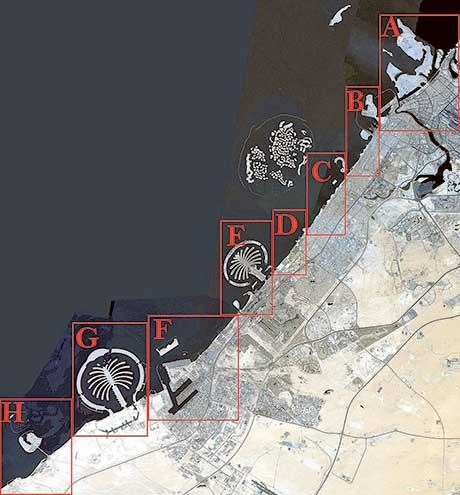
The section of Dubai coastline studied ranged from Al Mamzar Beach Park to the Dubai Waterfront Project and the Arabian Canal with an ultimate aim to calculate the length of the coast.
Statistics forthcoming from analysis will help leaders plan for future plans of the Dubai coast.
To accurately examine the changes using the satellite images, the study divided the coast into eight zones from A to H and showed “partial expansion” of the seashore due to projects such as the completed Al Mamzar Corniche Beach, Jumeirah Bay Island, Jumeirah One Beach renovation project and Pearl Jumeirah to Umm Suqeim 1 and 2 Beach upgrade project, Bluewaters Island and the Dubai Water Canal project.
The study also showed the construction of a number of breakwaters in order to protect the coast from medium-high waves, in addition to the construction of sand barriers in order to stop coastal erosion and sediment transport and to preserve the coast.
The study was conducted by Saeed Al Mansouri, head of the Applications Development and Analysis Centre at MBRSC and analyst Fatima Al Marzouqi.
“This study is the first of its kind in monitoring the changes the Dubai coastline has undergone. It took us three months [from January until March 2016] to conduct the study, during which we relied on the near infrared in DubaiSat-1 and DubaiSat-2 images to distinguish between land and water. We also applied geometric theories and laws to identify the coastline. The images used in the study were captured during the summer when there are no clouds, in order to get detailed and accurate results and analytical readings,” said Al Mansouri.


