Argentina's wild west
Alien-like rock formations and other surprises on a spectacular road trip
Salta, the provincial capital of north-west Argentina, is a city that seamlessly fuses a rustic charm with the European legacy of its colonial past. It is home to 536,000 friendly Salteños, making it a much more compact and intimate city than Argentina’s capital, Buenos Aires, whose population is three million.
Backpackers won’t have any difficulty finding accommodation here; our hostel was cosy and simple with a fun communal area that constantly had music and chatter emanating from it, along with occasional wafts of home-cooked food. We spent a relaxing two days wandering around and fattening up on the various asados (Argentinian barbecues), ice creams, empanadas and coffees on offer throughout the city.
The simple grid-like structure of the streets made it an easily navigable and pleasant place to stroll. We worked our way up to the Plaza 9 de Julio and then explored the network of streets branching off the main plaza. We then took a cable car up to the highest point to get a good view as the sun set behind the Andes.
At night we strolled around the city’s various peñas (dance halls serving food and drink) to sample the region’s signature music: zamba. This waltz-time music usually consists of an informal group including a guitar player, singer, bombo leguero (a traditional fur-skinned drum) and two dancers. Our trips to the peñas were washed down with fernet, the local aniseed-flavoured drink, and Coca-Cola.
If you’re looking to explore Salta’s nightlife, make sure you don’t head out too early. Things don’t get going until late in Argentina. At around 10pm, people start filling up tables in restaurants and sit down to a heavy carnivorous dinner and only get ready to go out from around midnight.
After a few days of relaxation in Salta, we decided it was time to head into the wild and dusty landscape beyond the city, so we hired a car. There are numerous car-hire places lining the streets near the main plaza. Because of the competition between them, we were able to bargain for a lower rate. We spent hours in the shop discussing routes and recommended stopping points.
While it is more expensive than taking a bus, hiring a car is definitely the better option and worthwhile because of the freedom it gives you. The tourist buses take you along the same route we drove, but are run on a tight schedule focused on getting you to the destination rather than enjoying the journey, which, for us, was what the trip was all about. With the map as our guide, we headed out into the Argentinian wilderness.
INTO THE WILD: Salta to Cachi through north calchaquÍ Valley
DISTANCE: 157km (three to four hours)
As we drove away from the city, the urban landscape filtered out into a series of rustic villages. We stopped a couple of times at a promising-looking bakery or grocery store to pick up some empanadas and various bits and bobs for a picnic. As we entered the Calchaquí Valley, the flat sooty landscape gave way to a more verdant backdrop.
Hues of mossy green and dashes of red lichen-coated boulders jutted out against a cloud-splattered sky. Taking our time, we stopped at every bend in the river and any other spot with a view that took our fancy, stepping out of the car to stretch our legs, take pictures and admire the beauty.
Eventually, tossing our map aside, we blindly followed a network of road tracks up and down the valley, retracing our steps when we reached a dead end. After following the road downhill, the land opened up into a grassy valley complete with a lake and wild horses. We settled down to picnic, only to be harassed constantly by a bored and hungry donkey.
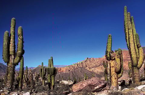
After spending our lunch wrestling half our picnic from the clutches of the donkey, we set out on the last leg of the journey to Cachi. Once we were out of the valley, the landscape immediately took on a different face. A sun-kissed valley spotted with cardon cacti spread out before us. The plants’ spikes glowed in the light of the quickly dropping sun, and we sped down the highway to make it to Cachi before sunset.
Cachi is a charming frontier town, made up of cobblestone and sparkling white adobe houses. There’s a compact plaza in the heart of the village where you can find Mercado Artesanal, a handicraft shop, which doubles as a tourist information centre. Towards the back of the plaza is an unassuming church, Iglesia San José, whose beauty is found in its graceful white arches and cardonwood ceiling.
With little to do in the small town we happily whiled away the time sampling the village’s various culinary specialities. The region is well known for its wholesome, rustic food. One local speciality is locro, a hearty and spicy stew. Best sampled at small restaurants and bakeries, Cachi’s home-made empanadas have also gained legendary status. Their fillings vary and include everything from a healthy mixture of quinoa and pumpkin to the more robust meat and cheese combo.
A WARM LOCAL WELCOME: Cachi to Cafayate, south Calchaquí Valley
DISTANCE: 164km (three to four hours)
Before heading to Cafayate, we had a quick breakfast in the bright winter sunshine. Having completely given up on our map, we left the town armed only with a few vague verbal directions on how to get to Cafayate. We had been warned about the road on Ruta 40, the road that ran between Cachi and Cafayate. It turned out to be less of a road and more of a dusty dirt track best tackled in 4x4s. We bumped along for a few hours, barely scraping through some areas, but enjoying the landscape.
We decided to stop off in the village of Molinos for a break and some food. We arrived there at around 1pm to find the residents taking their siesta. After roaming around the village’s five streets, we managed to find one lackadaisically staffed restaurant, which offered a menu where only half the options were available. A post-lunch stroll around this ghost town revealed a simple series of buildings and a church set against the stunning backdrop of the Andes.
In the next village, while searching for coffee, we followed the directions given to us by one of the residents, but instead, we found ourselves in the backyard of a house. A friendly old man appeared from inside and happily welcomed us with open arms. Pleased to have company, he brought out numerous photo albums full of postcards he’d received from passing tourists. He then retrieved a dusty guitar and, at our insistence, started strumming some tunes.
After our visit, we rattled along the road for another hour or two until we finally reached the banks of the Molinos River, which, because it was the dry season, had been reduced to a trickle. Following the river, we ended our second day in the slightly bigger town of Cafayate.
That night we decided to find out what a parilla was all about. Meaning ‘grill’ in English, the parilla is an Argentinian institution. Looking to pair a bit of local atmosphere with our food (a simple dish of goat meat), we chose the loudest parilla on the main square. The restaurant is full of simple chairs, tables and a giant barbecue that takes up half of the front of the restaurant.
We chose a seat outside, thinking we could enjoy the view and do some people watching. But instead, while we enjoyed our food, we had to contend with a mélange of hungry stray dogs doing their best to look cute in exchange for any scrap of meat.
NATURAL WONDERS: Cafayate to Salta City through the Quebrada de Cafayate
DISTANCE: 185KM (three hours)
The next morning we headed to Rio Colorado, a 5km walk out of town. We decided not to hire a guide and instead followed the river upstream past a series of waterfalls. Ice-cold pools, perfect for jumping into, were the perfect location for the empanada picnic we had prepared. Later we took Highway 68 and headed into the Quebrada de Cafayate, chasing the sun as we drove towards Salta. The landscape transformed into a series of bizarre rock formations.
Moulded over thousands of years by wind and rain, reddish sandstone facades plunged and jutted into all sorts of curious shapes. We had managed to get a new map from the Cafayate tourist office, which identified different stopping points and interesting rock formations that came with names like The Obelisk, The Amphitheatre or Devil’s Throat.
Despite its short distance, the route ended up taking longer than expected because of the volumes of pictures we took along the way. As time slipped away we resorted to taking drive-by shots of the surreal landscape with my friend at the wheel and me half dangling out of the car from the passenger seat, snapping away furiously as we made our way back to Salta.
This continued as the sun slowly sank behind the rocks, giving them a fiery red tinge that made taking photos even more irresistible. As dark descended, we made our way back to Salta with two memory cards full of photos and the taste of home-made empanadas and succulent grilled meat lingering in our memory.

