Mystery of the portolans
Little is known about how these medieval maps were made with fascinating accuracy
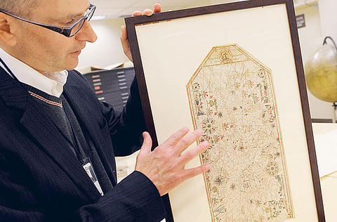
John Hessler, mathematical wizard and the senior cartographic librarian at the Library of Congress, slipped into the locked underground vaults of the library one recent morning. Hessler, 49, is a leading expert in trying to decode the mysteries of the maps. He approached a priceless 1559 portolan chart on the table before him, sketched in the hand of Mateo Prunes, the Majorcan map-maker. The nautical map of the Mediterranean and Black seas is inked on sheepskin.
It is a rare representative of one of the world's most enduring mysteries: Where and how did medieval mapmakers, apparently armed with no more than a compass, an hourglass and sets of sailing directions, develop stunningly accurate maps of southern Europe, the Black Sea and North African coastlines, as if they were looking down from a satellite, when no one had been higher than a treetop?
The earliest known portolan (PORT-oh-lawn) chart, the Carta Pisana, just appears in about 1275 — with no known predecessors. It is perhaps the first modern scientific map and contrasted sharply to the "mappamundi" of the era, the colourful maps with unrecognisable geography and fantastic creatures and legends. It bears no resemblance to the methods of the mathematician Ptolemy and does not use measurements of longitude and latitude.
Despite its stunning accuracy, the map "seems to have emerged full-blown from the seas it describes", one reference journal notes. No one today knows who made the first maps, or how they calculated distance so accurately, or even how all the information came to be compiled.
"The real mystery is that if you look at the notebooks the sailors used in making these charts, along with the coordinates and descriptions," Hessler says, tapping the glass that covers the ancient vellum, "you still couldn't make this map."
"People think maybe the Romans made the first ones and they've been lost, or the Phoenicians, or even aliens," says Evelyn Edson, author of The World Map: 1300-1492. "It certainly seems related to the introduction of the compass in the 11th century. But there is nothing at all to explain how they were made. ... It's been very tempting for people over the years to try to make up the answer."
"The ancient Greeks and Romans had traditions of mapmaking, there's Ptolemy and there's a line of progression," Hessler says. "But here, it just explodes out of nowhere. It appears to be a true invention of the Middle Ages."
Hessler's means of research isn't cultural or nautical — it is mathematical. He has taken 22 of the few hundred portolans known to be in existence and measured them against modern maps of the same area. He uses, say, 100 points of comparison on each map and applies complicated algorithms to calculate the differences between each point on each map.
Hessler compares these two maps on a computer-modelled overlay, with the scale of error then plotted onto a "deformation grid". He is then able to see where the charts were more accurate and where they were less accurate, from which he infers where sailing and close observation took place and which areas were more loosely charted. This, in turn, reveals more about the birthplace and methodology of the map. "That tells me different sources were used to make the same map," he says. "So now you start to discover where those different charts came from, and how they got to the mapmaker."
The maps' usage began to come to an end during transatlantic exploration. For all their regional accuracy, the mapmakers did not know how to calculate for the curvature of the Earth on a flat map. Still they were reliable guides to the known world for 400 years and they have concealed the secrets of their origins and methods for another four centuries, leaving the answers to the realm of novelists and storytellers.
Even with all the research that has been done on them the world over," Hessler says, looking up from the Prunes masterpiece, "there's not a single question about them that we can definitively answer."


