Dubai: Imagine that you have been tasked with coming up with names for more than 22,000 streets in Dubai. Yes, that’s a big number and it includes highways, internal roads, side roads, flyovers and intersections. All of these, every one of them, has to be renamed. A gargantuan task to say the least. The Roads and Transport Authority (RTA) and Dubai Municipality, in a joint project, are on to the task that will soon provide every corner of Dubai with a new name.
According to the project description shared with Gulf News by the authorities, each name has to be unique, reflecting the local heritage and culture as well as the environment surrounding the street.
Broadly, there are four categories in the naming convention, and each has a strategy. They are:
Follow a theme
“Names [of streets and roads] are selected based on their location and topography, which forms the theme,” said Maitha Bin Udai, CEO of RTA’s Traffic and Roads Agency. For example, streets fronting coastal areas and close to the Gulf are given names of fish, marine features, boats, etc, whereas streets that criss-cross the desert landscape are given names of trees, local plants, etc. Streets within the business districts are being given names associated with heritage, culture and history,” she added.
The idea behind this strategy is to make the association of name and place easier by reducing the complexity of the naming convention. “It was decided that these streets — which previously used to be referred by numbers — will now have names based on a theme.”
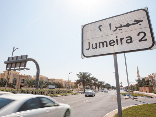
It is easy to understand the simplicity of this approach. Take the Jumeirah District, for example, Streets here will have names of marine characteristics like boats, fish, marine life, etc, since Jumeirah is all about the beach and sea. This analogous approach aids in name recall.
Similarly, streets in traditional business districts of Bur Dubai and Deira, keeping their surroundings in mind, will have names with historical and heritage recall, whereas inland areas of Mushrif and Al Aweer districts will bear names of local trees, famous Arab personalities and poets. Streets and roads in financial districts will have names of ancient Arab currencies and coins, explained Maitha. Also, the new address system will have internal streets named in a systematic manner.
All names are decided by a special committee of experts and academics. If you have a suggestion for any particular street or road, you can forward them to Dubai Municipality’s Planning Department.
Phase by phase
So far, around 500 streets that were previously known by numbers, have been named under the project that was launched in 2010.
Of more than 22,000 streets, approximately 10,000 will be named by the end of next year. Spread across Mirdif, Al Mizhar, Al Aweer, Khawaneej, Al Warqa’a, Al Barsha, Mushaisnah, Al Nahda, Nad Al Sheba and Dubai Investment Park as well as Business Bay, the current phase will cover the largest portion of the city.
The entire district of Jumeirah was covered first as a pilot project in 2008, while streets in Umm Suqeim, Al Sufouh, Downtown Dubai and Dubai Marina were covered during phase one, which began in 2010.
Apart from these areas, all newly developed neighbourhoods and streets will have names by default instead of numbers.
Of the most prominent streets that were recently renamed are Shaikh Mohammad Bin Zayed Road, Abdullah Omran Taryam Street, Al Saa’da Street, First Al Khail Street and Latifa Bint Hamdan Street, among many others.
Districts
The street renaming initiative is part of a comprehensive and integrated addressing system for the city that will see the city divided into 13 districts, which will be further divided into several sectors. Each sector will have streets with unique names as well as each building will have house numbers and GPS coordinates.
According to Maitha, the system was adopted following in-depth studies made by a team of experts who visited many big cities where they have successfully implemented such a system.
“Almost 90 per cent of the big cities across the world have an addressing system based on street names. That is why we launched the pilot project in Jumeirah which proved successful, so we went ahead with the plan to rename streets across the city,” said Maitha.
Direction
Apart from street names the new addressing system will be complemented by a new directional signage system, allowing motorists and emergency workers to find locations easily.
“The system includes route numbers, background colour of signboards, district names, cardinal direction, exit numbers along highways and building numbers which supplement each other to provide the ‘complete address’ of a particular location,” said Maitha.
As per the new system all highways and main roads will have route numbers as well as cardinal directions.
For instance, Shaikh Zayed Road is divided into north and south, and internal roads leading to the highway will show north and south signs. Streets leading to Shaikh Zayed Road (North) will head towards Sharjah, while streets leading to Shaikh Zayed Road (South) head to Abu Dhabi or Jebel Ali.
Similarly, Al Manara Road (east) leads inland, while Al Manara Road (west) leads towards the coast.
The same directional markings hold true for all the roads across the city.
Colours
For further ease of motorists, signboards will come in different colours, with boards on highways having a blue background and boards on internal roads a green background. All boards with exit signs leading from highways to communities will have a white background.
All boards showing tourist spots and landmarks will have a brown background while boards around construction sites will have a yellow background.
Of more than 100 sectors, seven have been covered under the new addressing system, which includes 50 main roads that were renamed.
Highlighting the important points of the addressing system Maitha said: “The street numbers are repeated in every sector, while the names are unique which helps enable faster delivery services, help emergency services (ambulance, police, etc) reach addresses easily and faster. With house numbers and GPS coordinates of each location, it becomes easier to navigate through each street and reach any corner of the city for regular motorists, taxis as well as tourists.”